


 RSS news
The consultation will run from the 7th of October to the 30th of November 2014. Comments received before the 31st of October 2014 will be, as much as possible, presented with the first results of this project during the IUCN World Parks Congress taking place in Sydney, Australia, 12-19 November 2014.
Contributors are not required to comment on the entire Consultation Document – any input will welcomed.
More information available here.

Connecting the dots: Integrating Biodiversity Observations to Better Track the CBD 2020 Targets.
Biodiversity: Journal of Life on Earth invites authors to share their experiences using systematic observations - including remote sensing observations - for monitoring change in biodiversity. The journal envisions submissions focusing on models for blending in-situ and remotely sensed data to fill gaps in the understanding of biodiversity status and trends.Biodiversity would welcome papers from members of the Biodiversity Indicators Partnership, working in the wider landscape of data and observation, and from contributors to the Group on Earth Observations Biodiversity Observation Network (GEO BON) exploring how Essential Biodiversity Variables could provide a framework for integrating biodiversity data. The journal also welcomes papers related to support offered by the Global Biodiversity Information Facility for implementing the Aichi Targets.
This special double issue will be published in September 2015, the midpoint of the 2020 mandate of the CBD, and following the release of the 4th edition of the Global Biodiversity Outlook at the October 2014 12th meeting of the CBD’s Conference of the Parties (COP-12) in Pyeongchang, Republic of Korea.
Prospective authors may wish to refer to UNEP/CBD/SBSTTA/17/2, Facilitating the Implementation of the Strategic Plan for Biodiversity 2011-2020 and the Aichi Biodiversity Targets through Scientific and Technical Means, prepared for the Seventeenth meeting of the CBD’s Subsidiary Body on Scientific, Technical and Technological Advice (SBSTTA-17); the SBSTTA-17 report (http://www.cbd.int/doc/?meeting=SBSTTA-17); and meeting documents for the Expert Workshop on Enhancing Biodiversity Data and Observing Systems in Support of the Implementation of the Strategic Plan for Biodiversity 2011–2020 (http://www.cbd.int/doc/?meeting=WS-BDOBS).
Please submit abstracts (250 words or less) in Times New Roman 12 pt. by 27 November 2014 to the Managing Editor, Vanessa Reid. A special board of editors will review the submitted abstracts. Only approved abstracts will be asked to proceed to final draft (4000-5000 words plus references and figures). Publication will be subject to peer review via Scholar One manuscripts online.

The Mediterranean Institute for Biodiversity and Ecology (IMBE, Aix-Marseille University, Aix-en-Provence, France), in its research group "Macroecology and Biogeography of Global Change (MacroBio)" has a PostDoc position open for applications. The post has a duration of 36 months, the initial contract is made for 18 months, being extended based on an assessment of performance. The position is funded by the European Commission through the FP7 Research Project LUC4C and affiliated to the French National Scientific Research Centre (CNRS).
The main topic is to improve the way LULCC processes are represented in the DGVM LPJmL through enhanced soil and vegetation process representation. Work should improve the model's capacity to project climate-LULCC interactions for the computation of net climate effects, and ecosystem services. One focus is on the representation of diverse agricultural management systems, cropland abandonment/afforestation and forest management, in order to develop ways to account for their effects on biochemical cycles and biophysics.
The successful candidate will have completed a doctorate in one of the environmental sciences. Substantial earth system modelling and programming skills are required, familiarity with highly modular C-code. Experience with Dynamic Global Vegetation Models will be a great advantage. The working language is English.
Interviews with successful candidates will begin after December 1, 2014. The position will be filled when a suitable candidate has been identified. To apply for this position, please send a letter of application, demonstrating your ability to understand the task, and your CV as soon as possible, but before the 31st of January 2015, by e-mail to Ms. Gabriela Boéri (Gabriela.Boeri@imbe.fr). For any questions about the task, working conditions, or the LUC4C project, please contact Dr Alberte Bondeau (alberte.bondeau@imbe.fr).

A new report "A world that counts - Mobilising the Data Revolution for Sustainable Development" was recently published. The document points out the need for globally available and freely accessible data to monitor progress of Sustainable Development Goals (SDGs), to hold governments accountable and foster sustainable development. This issue needs to be solved in a timely manner, as the gaps between developed and developing countries, between information-rich and information-poor people are increasing. Furthermore, better integrated, timely and validated information can lead to better decision-making and real-time feedback to the citizens. However, still some challenges remain, and the report points out recommendations to overcome existing limitations (countries have poor data, data arrives too late, many issues are barely covered), e.g. through a global "Network of Data Innovation Networks" that connects both organizations and experts.
The report was written by UN-IAEG, which is the United Nations Secretary-General’s Independent Expert Advisory Group on a Data Revolution for Sustainable Development and is available online here: http://www.undatarevolution.org/wp-content/uploads/2014/11/A-World-That-Counts.pdf

The third plenary of Intergovernmental Science-Policy Platform on Biodiversity and Ecosystem Services (IPBES) will be held from the 12.-17. January 2015 in Bonn, Germany where also EU BON partners will attend. The IPBES secretariat already released some information notes and documents for participants that plan to join the sessions. In addition to that, some working documents for IPBES-3 are released in the meantime, like the provisional agenda and others. There are also reports being published that are relevant for the work of biodiversity networks like EU BON. Interesting reports are for example the draft of the assessment on biodiversity and ecosystem services in Europe and Central Asia (where EU BON is mentioned as a relevant research network) and other working documents for the plenary.
Please find the documents under the following link that will guide you to the specific IPBES webpage: http://ipbes.net/plenary/ipbes-3.html#three
A new EU BON acknowledged paper "Advancing species diversity estimate by remotely sensed proxies: A conceptual review" has been recently published in the journal Ecological Informatics.
Abstract:
Many geospatial tools have been advocated in spatial ecology to estimate biodiversity and its changes over space and time. Such information is essential in designing effective strategies for biodiversity conservation and management. Remote sensing is one of the most powerful approaches to identify biodiversity hotspots and predict changes in species composition in reduced time and costs. This is because, with respect to field-based methods, it allows to derive complete spatial coverages of the Earth surface under study in a short period of time. Furthermore, remote sensing provides repeated coverages of field sites, thus making studies of temporal changes in biodiversity possible. In this paper we discuss, from a conceptual point of view, the potential of remote sensing in estimating biodiversity using various diversity indices, including alpha- and beta-diversity measurements.
Original Source:
Rocchini D, Hernández-Stefanoni J L, He KS (2014) Advancing species diversity estimate by remotely sensed proxies: A conceptual review. Ecological Informatics. DOI: 10.1016/j.ecoinf.2014.10.006
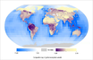
For the first time, a composite map of the world’s ecosystem assets has been produced, covering both marine and terrestrial realms. A report for the UNEP Division of Early Warning and Assessment by UNEP-WCMC presents global maps of assets such as biodiversity, freshwater resources and soil quality.
Natural capital is fundamental to human well-being. According to the Convention on Biological Diversity, at least 40 per cent of the world’s economy and 80 per cent of the needs of the poor are derived from biological resources. We are now facing a problem where natural capital has been harvested and degraded at a rate that threatens to undermine our well-being and future economic growth.
In their latest report UNEP-WCMC have combined information about key ecosystem assets into global maps covering terrestrial and marine realms. The assets included are freshwater resources, soil quality, organic carbon, terrestrial and marine biodiversity, and global fish catch (as a proxy for marine fish stocks). The report builds on a considerable body of work in the fields of natural capital accounting and the mapping of ecosystem services.
To read more and download the full report, please follow the link: http://www.unep-wcmc.org/news/towards-a-global-map-of-natural-capital

The Royal Museum for Central Africa (RMCA) in Tervuren (Belgium) is part of the FishBase Consortium and responsible for the information on the fresh- and brackish water fishes of Africa. Through an agreement with the Belgian Development Cooperation and as part of the FishBase program, the RMCA has five grants available for a 3-month training program in the use of FishBase and the taxonomy of African fishes.
The training includes three subsets:
- A detailed explanation of FishBase in all its aspects;
- A training in the taxonomy of African fishes;
- A case study based on data from FishBase or on taxa for which taxonomic problems have been encountered.
This course has been offered annually since 2005 and is held at the Royal Museum for Central Africa (Leuvensesteenweg 13, B-3080 Tervuren, Belgium). To apply for traineeship and for more information, please click HERE or HERE. Please note that for 2015, this course will be given in English only.
Questions? Contact Dimitri Geelhand de Merxem (dimitri.geelhand@africamuseum.be).

 Agenda CitizenScience_roundtable_EUBON 867.63 KB
Data sharing tools developed by an EU project are helping scientists worldwide understand more about the planet’s millions of species. A new article published on CORDIS and DAE looks into the benefits of the FP7 funded project VIBRANT.
One of the biggest challenges facing natural history experts is how to classify and share the mass of data constantly being collected on the Earth’s millions of species.
Based on Scratchpads, an open-source and free to use online platform, VIBRANT has helped create hundreds of new online communities.
The communities are linked together online and feed their data into the most important international biodiversity databases. VIBRANT helps users prepare papers for publication, build bibliographic databases and create reference collections of images and observations. A tool for rapid geospatial analysis of species distributions, a citizen-science marine monitoring platform as well as a biodiversity data analysis framework are also part of the ecosystem of services developed by VIBRANT.
ANTS TO BATS, LOBSTERS TO WHALES
VIBRANT has grown the number of user communities from around 100 under EDIT, an earlier EU project, to over 580 today. Some 6 500 active users are investigating an enormous range of species, at global scale. One site alone on stick insects (phasmids) has over 1 000 users, revealing the large community of people interested in culturing phasmid species.
‘My taxonomic background is in parasitic lice, of which there are about 5 000 particular species that live on about 5 000 mammals and 10 000 birds. Fighting to study that group, I found it enormously difficult to manage all this information,’ explained VIBRANT coordinator Dr Vince Smith, of London’s Natural History Museum.
Using the Scratchpads template, professional and amateur scientists, wherever they are based in the world, create their own subject-specific websites hosted at the museum.
They share their data by publishing it online, while retaining ownership over it and respecting the terms and conditions of the network set up by VIBRANT.
Scratchpads also provides ready access to a range of analytical tools, identification keys and databases that have been developed or enhanced throughout the project.
VIBRANT has also set up a novel, community peer-reviewed, open-access journal, the Biodiversity Data Journal (BDJ). Scratchpads users can input their research into a template which then makes it possible for them to produce a specific paper, publishing it internationally, online, in the BDJ and crediting them for the research. This is made possible via the development of the Pensoft Writing Tool (PWT), which is a leading example of the next generation of scholarly publishing. The PWT is acting as an integrated authoring, peer-review publishing and online collaborative platform which links the Scratchpads to the BDJ.
BIG DATA IN THE INTERNATIONAL CONSERVATION EFFORT
VIBRANT helps all researchers to easily share and link their data with major biodiversity repositories. For example, the Scratchpads collaborate with GBIF (the Global Biodiversity Information Facility), PESI (the EU’s Pan-European Species directories Infrastructure), the Biodiversity Heritage Library and the online collaborative Encyclopedia of Life, which is aiming to document all the planet’s 1.9 million known living species.
Dr Thomas Couvreur in Cameroon is maintaining a Scratchpads community on African palms and the tropical plant family Annonaceae. ‘They provide a professional platform for collaboration between my colleagues around the world, allowing us to share resources such as photos of species, datasets, bibliography and general information,’ he commented. Another coordinator, Eli Sarnat, in California, USA, has one on ants: ‘The platform has solved a big challenge for me: what biodiversity data I should be recording and how I should be recording it.’
The VIBRANT project ran from December 2010 to November 2013. It involved 17 partners from 9 countries, led by the Natural History Museum, London, and received FP7 funding of 4.75 million euros.
High-quality biodiversity data is essential for answering key questions on biodiversity in Europe, for example regarding the state and trends of species or for evaluating ecosystem services and functions on various scales. A new EU BON report "Gap analysis and priorities for filling identified gaps in data coverage and quality" evaluates the state of available biodiversity information and points out gaps of available biodiversity information sources.
The report aims to assess relevant data sources on biodiversity on a European and global scale. The assessment particularly evaluates the gaps of available biodiversity information sources and, after outlining the most important ones, identifies priorities for improving the data availability and gives recommendations of how they can be closed.
The report is divided into three main sections, starting first with an overall overview of gaps and limitations of biodiversity datasets. After outlining some general limitations of biodiversity data in Europe, the key findings from the specific analyses are summarized along with recommendations of how existing gaps can be closed. The last part presents a chapter containing the specific gap analysis for a selection of several main global and European datasets. The datasets represent some main sources for biodiversity data, either for specific realms (terrestrial, marine, freshwater), taxonomic groups, thematic fields (taxonomy, genetic databases) or networks of European test sites.
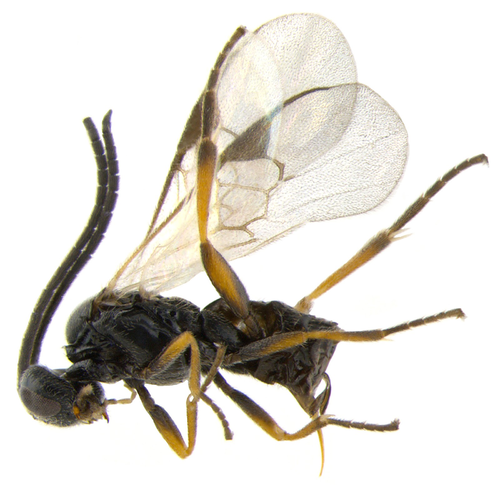
An innovative workflow reveals new research potential of the Barcode of Life Data Systems (BOLD). A recently published article in the Biodiversity Data Journal (BDJ) used specimen records downloaded from BOLD in tabular format and imported these into a human-readable text developed in manuscript within the Pensoft Writting Tool (PWT). Data were used to study the species distributions of ten Nearctic species of braconid wasps from the Microgastrinae subfamily.
 BOLD is originally designed to support the generation and application of DNA barcode data. However, the repository also holds unexplored treasures of additional data that provide unique potential for many other research uses.
Currently almost 4 million sequences (over 3.4 million of them DNA barcodes) are stored in BOLD, including coverage for more than 143K animal species, 53K plant species, and 16K fungi and other species, and this impressive storage of information is continuing to grow every day.
A team of researchers, led by Dr Jose Fernandez-Triana from the University of Guelph, Canada, have now explored how the unique amount of data stored on the BOLD platform can be utilised for new research purposes. Choosing tiny parasitic wasps for their case study they selected a sample of 630 specimens and 10 North American species. Data stored on BOLD were then used to uncover a significant number of new records of locality, provinces, territories and states.
The research was then secured a fast publication via BDJ, a community peer-reviewed, open-access, comprehensive online platform, designed to accelerate publishing, dissemination and sharing of biodiversity-related data of any kind.
"Import of structured data into human-readable text is important but it does not represent the whole story. More importantly, the data can be downloaded straight from the article text by anyone for further re-use, or be automatically exported to data aggregators, such as the Global Biodiversity Information Facility (GBIF). In this way, data platforms could get more peer-reviewed content from scholarly publications and scientists will be properly credited for their efforts" said Prof. Lyubomir Penev, founder of Pensoft Publishers.
Original Source:
Fernandez-Triana J, Penev L, Ratnasingham S, Smith M, Sones J, Telfer A, deWaard J, Hebert P (2014) Streamlining the use of BOLD specimen data to record species distributions: a case study with ten Nearctic species of Microgastrinae (Hymenoptera: Braconidae). Biodiversity Data Journal 2: e4153. doi: 10.3897/BDJ.2.e4153
Additional information:
The workflow is part of the Data Publishing Toolkit elaborated within the EU FP7 funded project EU BON (Grant agreement No 308454).


The World Conservation Monitoring Centre (WCMC) is looking to hire a Postdoctoral Scientist as part of the Nippon Foundation – University of British Columbia Nereus Program (www.nereusprogram.org). In association with the Department of Geography, University of Cambridge, this international collaboration is focused on the prediction of future global ocean fisheries, and will contribute to global sustainable fisheries and ocean management.
The role: The primary research focus of this position is to work in collaboration with UNEP-WCMC, Department of Geography, Cambridge University, and other partners on the Nippon Foundation – UBC Nereus Program to research the drivers of change in productivity in critical marine and coastal ecosystems and their impacts on fisheries-related ecosystem services.
Key responsibilities: The post holder will build upon the work of a previous post-doctoral scientist to simulate global patterns of marine ecosystem structure and function with an emphasis on fisheries production and food security. Specifically, they will improve the ecological realism of an existing dynamic ecosystem model recently published by WCMC and Microsoft Research (the Madingley model, www.madingleymodel.org) – extending the representation of climate and incorporating data on fishing pressure.
The candidate: The successful candidate will hold a PhD in marine or coastal ecology, or a related discipline with a strong emphasis on spatial analysis and modelling. They will have extensive knowledge of and experience in mathematical ecosystem modelling, programming and spatial statistics. They will also have carried out significant research at the global scale and will hold a proven record of academic performance. Furthermore, they will have an understanding of the essential characteristics of successful partnership-building and will be able to demonstrate the ability to work collaboratively and internationally.
Closing date: 2014-11-28
More information available in the ortiginal job offer: http://www.unep-wcmc.org/vacancies/postdoctoral-scientist-ad861

The European Journal of Taxonomy is a peer-reviewed international journal in descriptive taxonomy, covering the eukaryotic world. The content range from descriptions of new species to large inventories of different groups - so far more than 400 new species are described in EJT. Its content is fully electronic and Open Access. It is published and funded by a consortium of European natural history institutions. Neither authors nor readers have to pay fees.
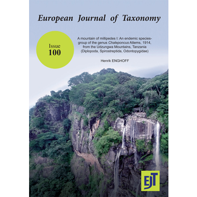
The 100th issue of EJT, which was published 24 October 2014, comprises a beautifully illustrated monograph on African millipedes, adding 20 new species to our list of new taxa. Author is Professor Henrik Enghoff from The Natural History Museum of Denmark, University of Copenhagen.
No 100 (2014): A mountain of millipedes I: An endemic species-group of the genus Chaleponcus Attems, 1914, from the Udzungwa Mountains, Tanzania (Diplopoda, Spirostreptida, Odontopygidae). Henrik Enghoff
EJT normally is an e-only journal, but on this occasion the editorial team has decided to print a limited number of hard copies, to be distributed amongst the Natural History Institutions around the world.
Professor Henrik Enghoff represents EU BON partner UCPH.
 EJT_100

BioVel is organizing a one-day workshop "BioVeL: In Practice and in Future". The event will take place on 13 Nov 2014 in Institut Océanographique, Paris, France. It aims at sharing BioVel experience obtained during the project's efforts to build a virtual laboratory for biodiversity research. Plans for the future of BioVel will be also presented.
|
BioVeL partners are pleased to invite you to
This one-day event aims at sharing with participants what we did and what we’ve learned during our efforts to build a virtual laboratory for biodiversity research. We will also present our plans for the future and invite the audience to take a role in it.
Detailed programme here
Follow us on Twitter: @bioveleu
|


Abstract: In an effort to increase conservation effectiveness through the use of Earth observation technologies, a group of remote sensing scientists affiliated with government and academic institutions and conservation organizations identified 10 questions in conservation for which the potential to be answered would be greatly increased by use of remotely sensed data and analyses of those data. Our goals were to increase conservation practitioners’ use of remote sensing to support their work, increase collaboration between the conservation science and remote sensing communities, identify and develop new and innovative uses of remote sensing for advancing conservation science, provide guidance to space agencies on how future satellite missions can support conservation science, and generate support from the public and private sector in the use of remote sensing data to address the 10 conservation questions. We identified a broad initial list of questions on the basis of an email chain-referral survey. We then used a workshop-based iterative and collaborative approach to whittle the list down to these final questions (which represent 10 major themes in conservation): How can global Earth observation data be used to model species distributions and abundances? How can remote sensing improve the understanding of animal movements? How can remotely sensed ecosystem variables be used to understand, monitor, and predict ecosystem response and resilience to multiple stressors? How can remote sensing be used to monitor the effects of climate on ecosystems? How can near real-time ecosystem monitoring catalyze threat reduction, governance and regulation compliance, and resource management decisions? How can remote sensing inform configuration of protected area networks at spatial extents relevant to populations of target species and ecosystem services? How can remote sensing-derived products be used to value and monitor changes in ecosystem services? How can remote sensing be used to monitor and evaluate the effectiveness of conservation efforts? How does the expansion and intensification of agriculture and aquaculture alter ecosystems and the services they provide? How can remote sensing be used to determine the degree to which ecosystems are being disturbed or degraded and the effects of these changes on species and ecosystem functions?
Original Source:
Rose R. A. et al. (2014) Ten Ways Remote Sensing Can Contribute to Conservation. Conservation Biology. Vol. 28, Issue 5. DOI: 10.1111/cobi.12397

On Tuesday 30 September 2014, the European Parliament Intergroup on "Climate Change, Biodiversity and Sustainable Development", in collaboration with the European Commission and the International Union for Conservation of Nature (IUCN), organised a full day conference entitled: "Nature-Based Solutions: Innovation potential for Smart, Sustainable and Inclusive Growth in Europe."
Bringing together 140 participants including representatives from the European Institutions, local and regional authorities, research institutes, NGOs and International organisations, as well as private sector representatives, this conference aimed at promoting the solutions that nature can offer in tackling major challenges, such as climate change and natural disasters, in ensuring food security to an increasing population, in protecting the health of European citizens, and the conservation of biodiversity in the EU and at the global level.
An EU-BON Workshop focusing on the DINA system - "Alpha version of mobilization system – the DINA-system MS141" - was hosted the 16. to 18. September 2014 by the Swedish Museum of Natural History in Stockholm.
Target group: programmers, developers and system engineers, but the workshop was open to anybody who was interested to learn more about the DINA-system.
Content included:
- Presentations from all DINA-partners
- APIs, service oriented architecture and road map for distributed development, guidelines and principles on how to build a module and join the DINA-system
- Case studies
- Delivery options: creating installations from hosted environment, virtual machines down to source code
For program, particpants list, presentations etc please vist the DINA wiki

The latest instalment of the Aichi Targets Passport is available now to download as an app from iTunes and Google Play.
As the flagship publication of the Biodiversity Indicators Partnership (BIP), the Aichi Targets Passport provides annual updates on the global biodiversity indicators that monitor progress towards the Strategic Plan for Biodiversity 2011-2020 and the underlying Aichi Biodiversity Targets.
 The suite of indicators presented in the Aichi Targets Passport was brought together by the BIP. They are as far as possible, global in their coverage, scientifically valid and peer reviewed, and relevant to the Aichi Biodiversity Targets. In particular, indicators are presented to highlight the progress that has been made towards each target so far and what baselines exist from which future progress can be monitored.
The Aichi Targets Passport was first released as a "proof of concept" in October 2012 and included one or two indicators for each Aichi Biodiversity Target. Since the release of the Beta version, the BIP Partnership has continued working to enhance and increase the number of global indicators available for each of the targets. In its app format, the information contained in the Aichi Targets Passport is at your fingertips at any time.
This latest edition of the Aichi Targets Passport has been released in tandem with the fourth edition of the Convention on Biological Diversity’s Global Biodiversity Outlook (GBO-4). In addition to information on which of the Aichi Biodiversity Targets is on-course to completion and which targets require more action, GBO-4 presents options that could halt further biodiversity loss.
The indicators presented in the Aichi Targets Passport are those contained in CBD decision XI/3 with some additional indicators that have been, or are being, developed to fill gaps.
To download the Aichi Targets Passport visit: http://www.bipindicators.net/resource/aichipassport
iTunes: http://goo.gl/dOWujN
Google Play: http://goo.gl/BN6AfG

